As of June 2013, a survey of existing climate indicators of both the atmosphere and ocean indicate an increased probability of above average rainfall for the upcoming austral summer in Northern Australia. A current La Nina-like pattern is likely to have reached its peak and will return to more typically neutral conditions by spring 2013, possibly reaching weak El Nino thresholds by early 2014. While El Nino would typically spell reduced rainfall potential in the SW Pacific, it is likely that the warm anomalous sea surface temperatures off NW Australia will persist, with increasing warm anomalies likely to develop along the Australian east coast contributing to increased rainfall potential along the eastern seaboard. Anomalous warming of the Gulf of Carpentaria and Coral Sea is likely to increase the convective potential of these areas, thus contributing to a raised likelihood of severe cyclone development.
Analysis of a range of atmospheric indicators from the past 20 years suggests that the 2008-2009 is the closest analogue for conditions in the upcoming season, with the Southern Oscillation Index (SOI), and the Quasi Biennial Oscillation (QBO), in a similar phase step and trend, as well as marked similarities noted for June 2008 and June 2013 for anomalous rainfall and temperature across Australia. 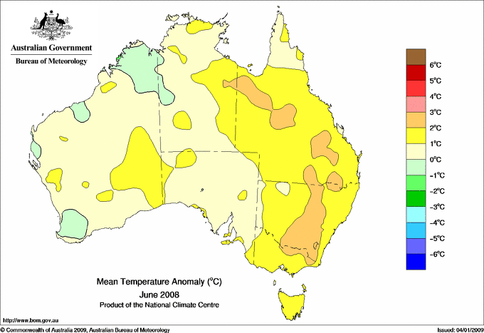

Above: Comparative analysis of June 2008 and June 2013 maximum temperature anomalies.


Above: Comparative analysis of June 2008 and June 2013 rainfall anomalies.

Above: Rainfall anomalies – northern Wet Season 2008-2009

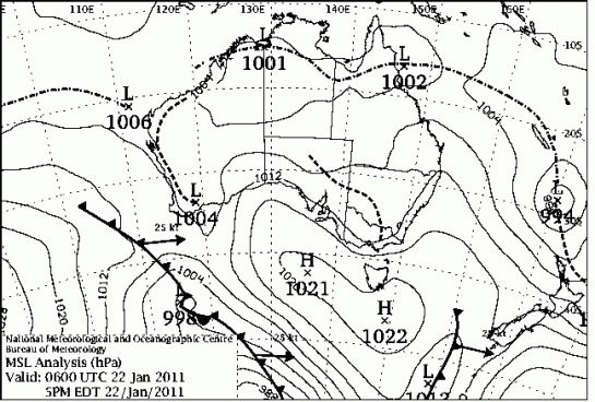
Above: Cyclones in the Australian Region, northern Wet Season, 2008-2009